Mandatory Pre-Race Meeting: Evening, Friday, DATE TBD, Lo-Inyo Elementary School, Multipurpose Room, 223 East Locust Street, 1.5 blocks east of 395 (north end of town).
Start Time: 7:00am, Saturday, DATE TBD.
End Time: 100pm, Sunday, DATE TBD (30-hour time limit).
Post-Race Party: 100-230pm, Sunday, DATE TBD, Lo-Inyo Elementary School, Multipurpose Room, 223 East Locust Street, 1.5 blocks east of 395 (north end of town). Pizza and drinks will be served.
Support Crews are Optional. Even those with a support crew / vehicle will have to demonstrate a significant ability to run without coddling as the upper 13 miles of Horseshoe Meadow Road and the upper 3.6 miles of Whitney Portal Road are closed to cars and could be covered in snow. (Additionally, runners will have to trek 3.6 miles back down from the finish line to the car parking area at the gate after completing the race.) There are also stretches of up to 15 miles between aid stations.
Pacers will be allowed for the three ascents (one on the Cerro Gordo climb, starting at Keeler, and two on the Horseshoe Meadow and Whitney Portal ascents, starting at the road closure gates in both instances).
There will be a Mandatory Gear list; runners will be required to run with a hydration vest / backpack and various items.
All runners will carry / wear a GPS tracking unit with tracking service (provided by the race organizers).
Many more details will be posted in November, and beyond (including the actual race rules.)
PERMITS: This event will be held under special use permits from the Inyo National Forest, Inyo County, and the California Department of Transportation, and is additionally overseen by the California Highway Patrol. (If one of these agencies won’t issue us a permit, this race could be cancelled. Please keep that in mind!)
In accordance with Federal law and U.S. Department of Agriculture policy, this institution is prohibited from discriminating on the basis of race, color, national origin, sex, age or disability. (Not all prohibited bases apply to all programs.)
To file a complaint of discrimination, write USDA, Director, Office of Civil Rights, Room 326-W, Whitten Building, 1400 Independence Avenue, SW, Washington, D.C. 20250-9410 or call (202) 720-5964 (voice and TDD). USDA is an equal opportunity provider and employer.
The FIRST TIME EVER Badwater® Cerro Gordo will be an invitational race with a field limit of 100 racers. We anticipate an entry fee of $495. If you hope to compete in the inaugural edition, please send a postcard (no larger than 5″x7″) to AdventureCORPS, Inc. 638 Lindero Canyon Road #311, Oak Park, CA 91377 USA with the following information neatly and permanently inscribed upon it in this order:
• Name, Birthday, and gender
• Email address
• Street Address, City, State, Country, and Nationality (the latter is not the same as ethnicity…)
• Your experience of any kind at any BADWATER events
• Your top three most badass (but non-BADWATER) ultra running accomplishments, with a particular emphasis on 100-mile (or longer) non-stop races, especially really tough ones. At least one of them must have been in the past 24 months. Include race name, date, distance, finishing time, etc.
• Anything else you’d like to add that is particularly relevant, such as experience in cold weather, at high elevation, and/or self-supported racing or adventuring.
By sending us this postcard, you agree to the following:
- You hope to get into the race and if you are invited, you will then complete the online registration process within seven days, paying the entry fee and mailing us the hard copy of your waiver.
- You give us permission to post any or all of your postcard (minus your bday, street address, and email address) to our website, BADWATER magazine, and/or social media.
- You are an awesome human being of outstanding character.
- You are physically, mentally, and spiritually prepared for the task of not just starting, but FINISHING, this extremely challenging race.
We will review postcards and hope to send out the first round of invitations in the near future. (This is pending race permit approvals.)
Thank you for your interest and enthusiasm!
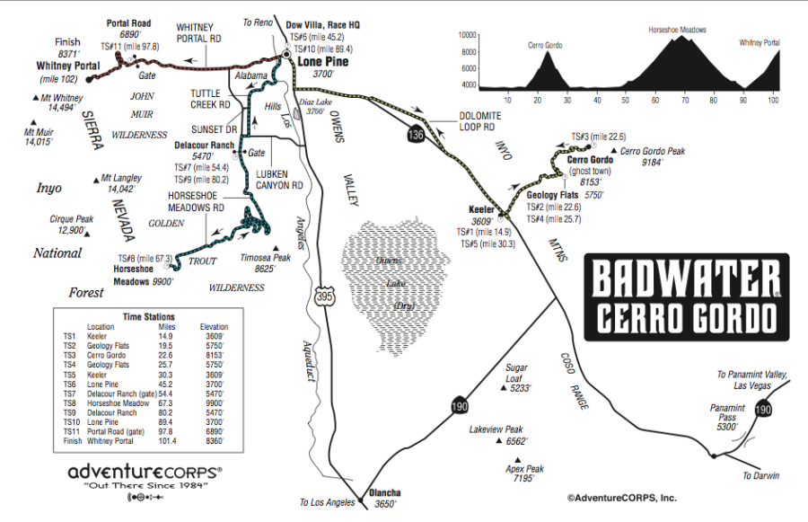
The Badwater Cerro Gordo course is 101.4 miles (165km) and covers three mountain pass ascents for a total of over 17,000’ (5,800m) of cumulative vertical ascent and 12,700’ (4450m) of cumulative descent.
The start line is in Lone Pine, CA and begins by crossing the Owens Valley to Keeler and than proceeds with a 5,500 foot dirt road ascent to the ghost town of Cerro Gordo. Runners will then return to Keeler and Lone Pine for a total of 45.2 miles. From there, they will run to the summit of Horseshoe Meadow (elev. 10,000 feet / 3048m), and back, for a total of 89.4 miles. After passing back through Lone Pine, the runners will tackle the final dramatic ascent to the highest paved point on Mt. Whitney, Whitney Portal at 8,360’ (2530m). Whitney Portal is the trailhead to the Mt. Whitney summit, the highest point in the contiguous United States.
Aid Stations with water (sometimes hot), PB&J sandwiches, fruit, and other snacks will be at the following locations. Runners are also expected to provide “drop bags” with their personal items (food, clothing, batteries, etc.) to be delivered to each of these locations on their behalf:
TS1 Keeler, mile 14.9, elevation 3609′
TS2 Geology Flats, mile 19.5, elevation 5750′
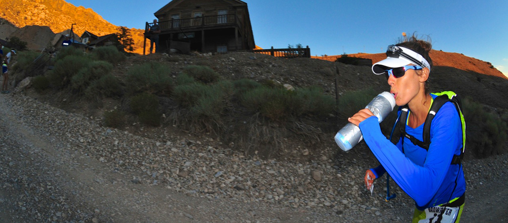
TS3 Cerro Gordo, mile 22.6, elevation 8153′
TS4 Geology Flats, mile 25.7, elevation 5750′
TS5 Keeler, mile 30.3, elevation 3609′
TS6 Lone Pine, mile 45.2, elevation 3700′
TS7 Delacour Ranch (Gate), mile 54.4, elevation 5470′
TS8 Horseshoe Meadow, mile 67.3, elevation 9900′
TS9 Delacour Ranch, mile 80.2, elevation 5470′
TS10 Lone Pine, mile 89.4, elevation 3700′
TS11 Portal Road (gate), mile 97.8, elevation 6890′
Finish: Whitney Portal, mile 101.4, elevation 8360′