Badwater Cerro Gordo
We are excited to announce that we are making progress on the BADWATER® Cerro Gordo concept and race. We’ve had a map created and a simple race logo.
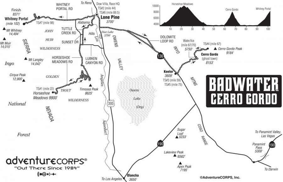
The Badwater Cerro Gordo 102-mile footrace will be based upon the Badwater 135 route used in 2014, but excluding the 33-mile out-and-back section between Keeler and Darwin. It will cover 102 miles (166km) non-stop from Lone Pine, CA to the summit of Horseshoe Meadow (elev. 10,000 feet / 3048m), then across the Owens Valley to a 5,500 foot dirt road ascent to the ghost town of Cerro Gordo, and then, after passing back through Lone Pine, a final dramatic ascent to the highest paved point on Mt. Whitney, CA. The start line is at Lone Pine, CA, and the race finishes at Mt. Whitney Portal at 8,360’ (2530m). The Badwater Cerro Gordo course covers three mountain pass ascents for a total of over 17,000’ (5,800m) of cumulative vertical ascent and 12,700’ (4450m) of cumulative descent. Whitney Portal is the trailhead to the Mt. Whitney summit, the highest point in the contiguous United States.
It will be a terrific winter counterpoint to the Badwater 135!
The first edition will be held in Winter 2015 / 2016 or 2016 / 2017. Details forthcoming on the event webpage here on the BADWATER.com site.