| Distance |
Landmark |
Elevation |
|
NOTE: TL = Traffic Light; SS = Stop Sign; T-Int = T-Intersection
|
|
| 0.0 |
Start west on Whitney Portal Road from Brewery Street |
3740′ |
| 0.4 |
Left on Tuttle Creek Road NO SUPPORT VEHICLES NEXT 3.1 MILES |
3780′ |
| 0.6 |
Pass Portagee Joe Campground on right (toilet 50 yards west of road) |
3790′ |
| 1.55 |
Cross LA Aqueduct |
3800′ |
| 3.8 |
Pass Hopalong Cassidy House on Right |
4500′ |
| 4.1 |
Pass Thundercloud Lane on Left VEHICLE SUPORT BEGINS |
4580′ |
| 5.8 |
Right on Lubken Canyon Rd. (SS, T-Int) |
4700′ |
| 6.2 |
Left on Horseshoe Meadows Rd. (SS, T-Int) |
4800′ |
|
Dangerous, narrow area! No slow driving or stopping on road!
|
|
| 9.2 |
DeLaCour Ranch (Switchback #1 starts) TOILET |
5470′ |
| 10.6 |
Enter Inyo National Forest |
6000 |
| 11.65 |
Switchback #2 starts |
6400′ |
| 13.3 |
Switchback #3 starts |
7000′ |
| 14.8 |
Switchback #4 starts |
7600′ |
| 15.9 |
Switchback #5 starts; watch for rocks on road |
8000′ |
| 16.6 |
Cell Service ends for Verizon; AT&T continues to work for 1.4 miles |
|
| 16.7 |
Switchback #6 starts |
8400′ |
| 16.9 |
Switchback #7 starts |
8500′ |
| 18.0 |
Walt’s Point (AT&T cell service ends) |
9000′ |
| 19.0 |
Summit, followed by short downhill |
9300′ |
| 19.9 |
Low Point; resume climbing |
9050′ |
| 21.6 |
“Wood Gathering Prohibited” / Gate |
9600′ |
| 21.7 |
Stay left / Straight (Old Pack Station location) |
9700′ |
| 21.9 |
Stay left / Straight towards Cottonwood Pass |
9720′ |
| 22.1 |
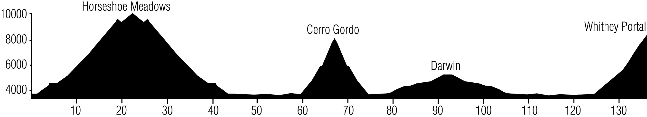
Left into Day Use area: Time Station #1 (6135′ cumulative ascent) |
9730′ |
| 22.2 |
Toilet on short loop road |
9730′ |
| 22.3 |
Right to return down/east on Horseshoe Meadows Rd. (SS, T-Int) |
9730′ |
| 24.4 |
Low Point; begin 250′ ascent |
9050′ |
| 25.25 |
Summit; begin long descent |
9300′ |
| 26.4 |
Walt’s Point (AT&T cell service resumes) |
9000′ |
| 27.4 |
Switchback #7 starts |
8500′ |
| 27.8 |
Switchback #6 starts |
8400′ |
| 27.9 |
Verizon cell service resumes |
|
| 28.4 |
Switchback #5 starts |
8000′ |
| 29.4 |
Switchback #4 starts |
7600′ |
| 30.9 |
Switchback #3 starts |
7000′ |
| 32.6 |
Switchback #2 starts |
6400′ |
| 35.0 |
DeLaCour Ranch (Switchback #1) TOILET |
5470′ |
| 38.4 |
Right on Lubken Canyon Rd. |
4800′ |
| 38.5 |
Left on Tuttle Creek Road |
4700′ |
| 40.0 |
Cross Sunset Drive (Crew vehicles go west to meet runners at Mile 43.9) |
4580′ |
| 40.2 |
Pass Thundercloud Lane on Right NO SUPPORT VEHICLES NEXT 3.1 MILES |
4580′ |
| 42.8 |
Cross LA Aqueduct |
3800′ |
| 43.8 |
Pass Portagee Joe Campground on left (toilet 50 yards west of road) |
3790′ |
| 43.9 |
Right on Whitney Portal Rd. (SS, T-Int) VEHICLE SUPPORT RESUMES |
3780′ |
| 44.4 |
Right on Hwy 395 (TL) |
3740′ |
| 44.5 |
Pass Dow Villa on Left: Time Station #2 |
3740′ |
| 45.9 |
Pass last gas and food: Chevron / Lee’s Frontier Deli on right |
3700′ |
| 46.2 |
Left on SR 136 / SR 190 |
3690′ |
| 48.8 |
Cross Owens River |
3610′ |
| 49.6 |
Left onto Dolomite Loop |
3600′ |
| 54.2 |
Left onto Hwy 136 (SS, T-Int) WATCH FOR SOFT SHOULDERS |
3440′ |
| 59.1 |
Pass Cerro Gordo Rd. on right in Keeler |
3680′ |
| 59.4 |
Left on Cerro Gordo Rd: Time Station #3 TOILET NO SUPPORT VEHICLES NEXT 15.4 MILES |
3680′ |
| 64.0 |
False Summit “Geology Flats” (Water/Ice) (8650′ cumulative ascent) |
5750′ |
| 65.0 |
Enter Joshua Tree forest |
6200′ |
| 65.8 |
“No Hunting” sign on wooden mining equipment on left |
6930′ |
| 67.1 |
American Hotel in Cerro Gordo: Time Station #4 TOILET (11,000′ cumulative ascent) |
8000′ |
| 70.2 |
False Summit “Geology Flats” (Water/Ice) |
5750′ |
| 74.8 |
Left onto Hwy 136 (SS, T-Int): Time Station #5 VEHICLE SUPPORT RESUMES |
3670′ |
| 79.3 |
Straight onto Hwy 190 (No Cell Service until Mile 102) |
3830′ |
| 80.6 |
4000′ Elevation Sign on left |
4000′ |
| 82.6 |
Gunsight Pass |
4340′ |
| 85.9 |
Gravesite / Large Cross on left |
4540′ |
| 90.7 |
Mile Marker 36.0 on right |
5000′ |
| 91.25 |
Large pull-out on right: Time Station #6 (0.9 mile before Darwin turn-off) |
5150′ |
| 96.5 |
Gravesite / Large Cross on right |
4540′ |
| 99.8 |
Gunsight Pass |
4340′ |
| 100.7 |
“100 MILES” painted on road on left side |
4160′ |
| 101.9 |
4000′ Elevation Sign on right |
4000′ |
| 103.1 |
Straight onto Hwy 136 at Hwy 190 junction (Cell service resumes) |
3830′ |
| 107.7 |
Pass Cerro Gordo Road on rightinI Keeler (former TS #3/5) |
3670′ |
| 113.0 |
Pass Dolomite Loop on right |
3440′ |
| 117.2 |
Pass Dolomite Loop on right again |
3600′ |
| 118.0 |
Cross Owens River |
3610′ |
| 120.7 |
Right on Hwy 395 (SS, T-Int) |
3690′ |
| 122.4 |
Pass Dow Villa on right: Time Station #7 |
3740′ |
| 122.5 |
Left on Portal Road (TL) |
3740′ |
|
No slow driving or stopping on road!
|
|
| 125.6 |
Pass Horseshoe Meadow Rd. on left |
4520′ |
| 126.8 |
Pass Cuffe Ranch on right |
5100′ |
| 128.1 |
Pass Olivas Ranch Rd. on left |
5300′ |
| 129.0 |
Pass Lone Pine Campground on left |
5700′ |
|
Dangerous, narrow area! No slow driving or stopping on road!
|
|
| 130.8 |
Large pullout on right before switchbacks section: Time Station #8 |
6890′ |
| 131.8 |
“The Switchback” |
7215′ |
| 132.4 |
Vista Point on left |
7400′ |
| 133.4 |
Whitney Portal Recreation Area sign |
7700′ |
| 133.7 |
Family Campsites on left |
8100′ |
| 134.3 |
Overflow Parking Lot on left |
8200′ |
| 134.4 |
Finish Line 100 yards beyond Mount Whitney Trail sign (17,000′ cumulative ascent) |
8360′ |
|
Copyright ©AdventureCORPS, Inc.
|
|


