Category: Race Info

Badwater Cerro Gordo

CerroGordoLogo

We are excited to announce that we are making progress on the BADWATER® Cerro Gordo concept and race. We’ve had a map created and a simple race logo.

The Badwater Cerro Gordo 102-mile footrace will be based upon the Badwater 135 route used in 2014, but excluding the 33-mile out-and-back section between Keeler and Darwin. It will cover 102 miles (166km) non-stop from Lone Pine, CA to the summit of Horseshoe Meadow (elev. 10,000 feet / 3048m), then across the Owens Valley to a 5,500 foot dirt road ascent to the ghost town of Cerro Gordo, and then, after passing back through Lone Pine, a final dramatic ascent to the highest paved point on Mt. Whitney, CA. The start line is at Lone Pine, CA, and the race finishes at Mt. Whitney Portal at 8,360’ (2530m). The Badwater Cerro Gordo course covers three mountain pass ascents for a total of over 17,000’ (5,800m) of cumulative vertical ascent and 12,700’ (4450m) of cumulative descent. Whitney Portal is the trailhead to the Mt. Whitney summit, the highest point in the contiguous United States.

It will be a terrific winter counterpoint to the Badwater 135!

The first edition will be held in Winter 2015 / 2016 or 2016 / 2017. Details forthcoming on the event webpage here on the BADWATER.com site.

CerroGordoMap_web

Badwater 135 Course Description

Download as PDF.

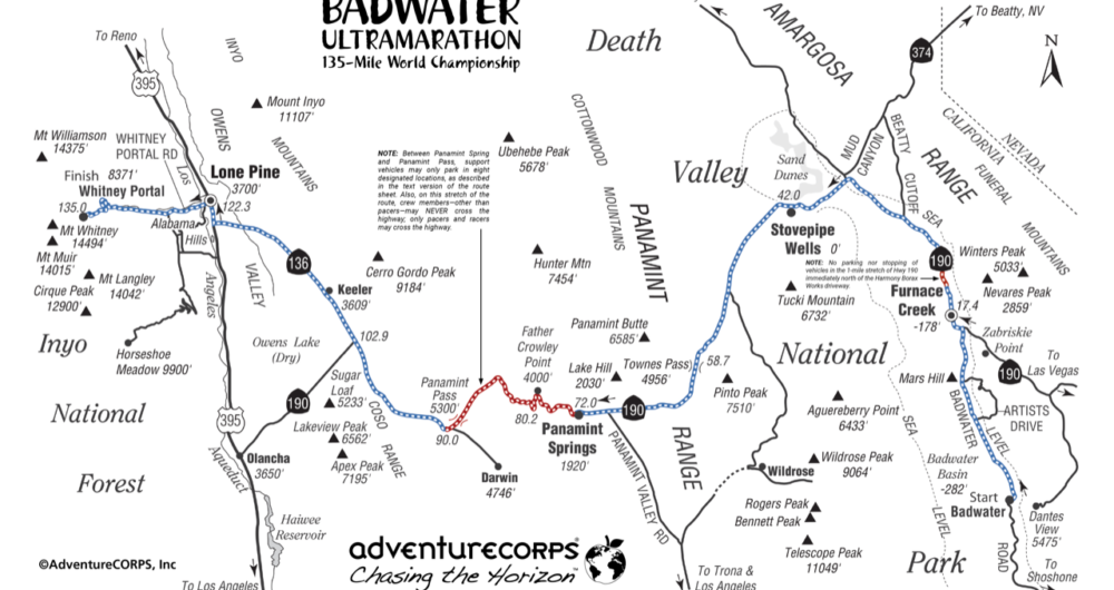
Badwater Basin, Death Valley (282ft / 85.5m below sea level), Mile Zero (Start Line)
The race begins here adjacent to a pool of saltwater located at the lowest place in North America. There are toilets, but no other services.

Furnace Creek Ranch (170’ / 51m below sea level), 17.5mi / 28.2km (Time Checkpoint #1)
The first oasis in our journey. Two hotels, gas station, general store, restaurants, camping, and ice are available. Stock up here on ice, water, food, supplies, and gas both before the race and when you pass through during the race!

Stovepipe Wells (Sea Level), 42.2mi / 68km (Time Checkpoint #2)
A general store, gas station, restaurant and motel. Location of the race’s Medical HQ for most of first 15 hours of the race. It is critical that you stock up on ice, water, food, supplies, and gas when you pass through here during the race!

Towne Pass (4956’ / 1511m), 58.7mi / 94.5km (Time Checkpoint #3)
From Stovepipe Wells, it’s 17-mile long ascent with 5000’ of elevation gain to the highest point of the race course. There are two important landmarks along the ascent: 1) The 2000′ Elevation Sign located at Mile 50.8, which must be passed by ALL runners by 1000am on the first morning of the race. 2) The Wildrose Parking Lot on the right at Mile 51.2, with lots of space for support crews to park, plus toilets.

After cresting the Towne Pass summit and passing Time Checkpoint #3, it’s a 10-mile long descent with 3000’ feet of elevation loss into the Panamint Valley. On both sides, it’s a steep and narrow road with limited opportunities to park. Support vehicles, crews, and runners must be cautious and extra aware of the traffic.

Panamint Springs Resort (2000’ / 610m), 72.7mi / 117km (Time Checkpoint #4)
Gas station, mini-mart, plus restaurant and motel. We rent out “The Cottage” as a way station for any and all race entrants and crews to use during the race: Bring your own towel, soap, and shampoo and make a big effort to keep the room and bathroom tidy. It is critical that you stock up on ice, water, food, supplies, and gas when you pass through here during the race! (Get some real food for both runners AND crew!)

After passing Panamint Springs, a long, steep climb follows on a steep and narrow road with limited opportunities to park. Support vehicles, crews, and runners must be cautious and extra aware of the traffic, and ONLY park in the eight designated parking zones between Panamint Springs Resort and unmarked “Panamint Pass” at mile 84.9. This is known as the Father Crowley Climb.

Father Crowley’s Turnout (4000’ / 1219m), 80.65mi / 130km
The bathrooms and parking lot that designate this viewpoint are not the top of this ascent, though you may hope so. The road continues to rise to 5000’ / 1524m over rolling hills, then eventually descends into the Owen’s Valley.

Darwin Turn-Off (5050’ / 1540m), 90.7mi / 146km (Time Checkpoint  #5)
There are no services here, but just a few miles to the south of our route is the small inhabited ghost town of Darwin, the website for which touts “NO broadcast TV; NO AM/FM radio, NO cell signal; NO stores; NO restaurants.” The Darwin time station is where the race usually starts to get serious for all entrants. Look for “gunsite notch” about 9.3 miles ahead to indicate your 100-mile mark! The generally flat or slightly downhill stretch ahead can be tedious and demoralizing; Mt. Whitney is visible ahead and never seems to get closer! See a video of this location.

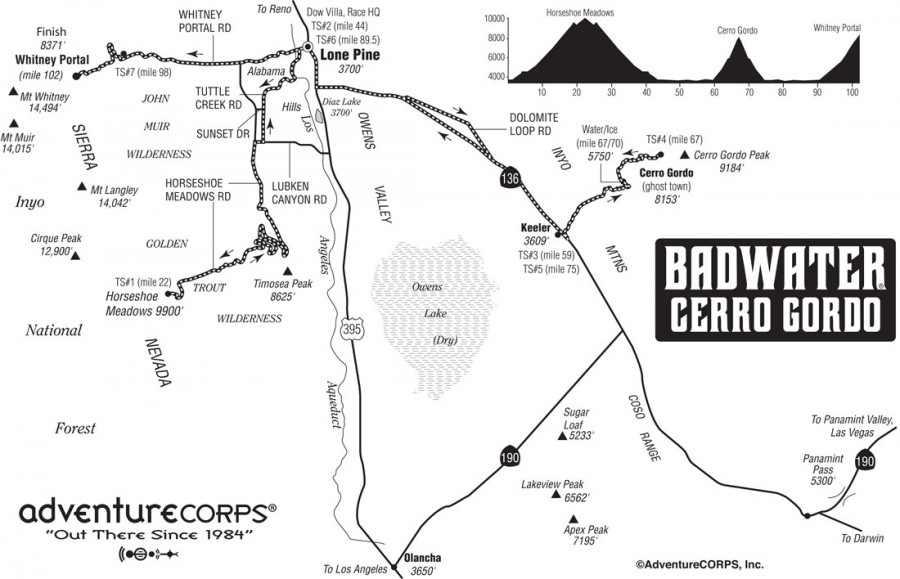
Keeler (3610’ / 1100m), 108.4mi / 174km (Time Checkpoint #6)
This is a small mining town with no facilities which abuts the Owens Dry Lake Bed on the left of the highway. Amazing views of Mt. Whitney and the Sierra Nevada abound. A dirt road to the right ascends to Cerro Gordo, an authentic ghost town high in the mountains.

Lone Pine (3610’ / 11km), 122.7mi / 197.5km (Time Checkpoint #7)
Lone Pine offers the weary runner and crew all the amenities of a real town: café fare, fast food, pizza, restaurants, motels, gas stations, a grocery store, and much more, not to mention our Race Headquarters at the Dow Villa. Restock here for the climb to Whitney Portal as there no services after Lone Pine. Turn left onto the Whitney Portal Road to begin the final leg, the longest and steepest climb of the race (13 miles or 21km with 5000 feet or 1524m of elevation gain). Temperatures will steadily decrease during the ascent (though depending on time of day). As you ascend Mt. Whitney, be sure your support vehicle is always parked completely off of the road and that you do not block traffic, not even for a moment.

Portal Road / Base of the Switchbacks (6890’ / 2100m), 131.1mi / 211km (Time Checkpoint #8)
After the turn from Hwy 395 in Lone Pine, it’s 8.3 miles or 13.4km to the final Time Checkpoint, located at the start of the switchbacks. For nighttime finishers, be prepared with extra layers of clothing; at night it can approach freezing temperature. The Portal Road is steep and very narrow: please drive and park extra carefully all the way to the finish! 

Mt. Whitney Trailhead, (8360’ / 2548m), 135mi / 217km
Congratulations! You have finished The World’s Toughest Foot Race! A small burger shack / shop are open during daylight hours (and they serve the BEST pancakes, fries, and burgers.) There is also a stocked fishing pond and a campground (because, of course, after running 135 miles, you really want to go fishing and camping!).

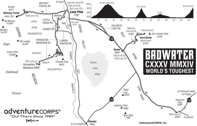
For all the Badwater 135 race route details, click here.

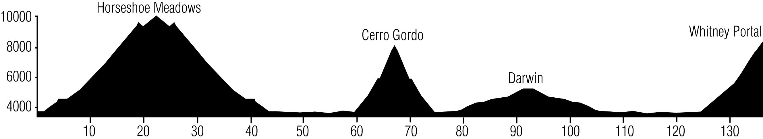
Course Profile Breakdown

Flat Miles:

Badwater to Stovepipe Wells 41 miles
Panamint floor 2 miles
Darwin flats 4 miles
Owens Valley to Lone Pine 22 miles
69 miles total

Uphill Miles:

Stovepipe Wells to Townes 18 miles + 5,000 ft.
Panamint grade (west) 15 miles + 3,400 ft.
Lone Pine to Whitney Portal 13 miles + 4,600 ft.
46 miles total +14,600 ft. total

Downhill Miles:

Townes to Panamint Valley 8 miles – 3,400 ft.
Darwin to Owens Valley 12 miles – 1,300 ft.
20 miles total – 6,100 ft. total


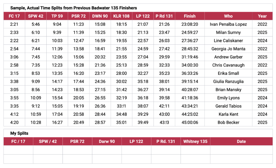
Below are real, actual time splits from 2015, 2016, and 2017 racers, which are far more useful than average speed time splits, which vary widely in reality due to the severe changes of topography along the course, not to mention the heat, or cold, wind, and more.
Note there is some range: some runners “fall behind” or “make up time” in various stretches depending on how they feel, eat, drink, and many other factors. This is why we included real-time splits for several different runners in the 34-hour, 40-hour, 44-hour, and 46-hour range. Everything is in elapsed time.

2014 Badwater 135 Route

Race Route: 2014 Edition

Course Profile

Garmin GPS Map

Behold the new and improved 2014 edition of the Badwater 135, the world’s toughest foot race!

Essential Race Route for 2014
Start in Lone Pine and run up Tuttle Creek
Run to the top of Horseshoe Meadow (23 miles uphill with 6500 feet of elevation gain)
Run back down to Lone Pine
Run southeast to Keeler on Hwy 136
Run up Yellow Grade Road to Cerro Gordo (7.5 miles uphill with 5500 feet of elevation gain)
Run back down Yellow Grade Road to Hwy 136
Run southeast on Hwy 136 / hwy 190 to the Darwin Turn-Off.
Turn around and run Hwy 190 / Hwy 136 back to Lone Pine
Finish by running from Lone Pine to Whitney Portal (13 miles uphill with 5000 feet of elevation gain)

Compared to the traditional route, the 2014 version has over 17,000’ (5,200m) of cumulative vertical ascent and 12,700’ (3900m) of cumulative descent, while the traditional Death Valley-based route has 13,000’ (3962m) of cumulative vertical ascent and 4,700’ (1433m) of cumulative descent. Though the 2014 edition does not start in Badwater and traverse Death Valley and Panamint Valley, the actual topography of the new route is significantly more challenging and very much worthy of the moniker, “world’s toughest foot race.”

Badwater135_2014_map800

Route Landmarks


2014 Badwater 135 Ultramarathon Route Landmarks

Created with GPS measurement: June 2014.

Distance Landmark Elevation
NOTE: TL = Traffic Light; SS = Stop Sign; T-Int = T-Intersection
0.0 Start west on Whitney Portal Road from Brewery Street 3740′
0.4 Left on Tuttle Creek Road             NO SUPPORT VEHICLES NEXT 3.1 MILES 3780′
0.6 Pass Portagee Joe Campground on right (toilet 50 yards west of road) 3790′
1.55 Cross LA Aqueduct 3800′
3.8 Pass Hopalong Cassidy House on Right 4500′
4.1 Pass Thundercloud Lane on Left VEHICLE SUPORT BEGINS 4580′
5.8 Right on Lubken Canyon Rd. (SS, T-Int) 4700′
6.2 Left on Horseshoe Meadows Rd. (SS, T-Int) 4800′
Dangerous, narrow area! No slow driving or stopping on road!
9.2 DeLaCour Ranch (Switchback #1 starts)  TOILET 5470′
10.6 Enter Inyo National Forest 6000
11.65 Switchback #2 starts 6400′
13.3 Switchback #3 starts 7000′
14.8 Switchback #4 starts 7600′
15.9 Switchback #5 starts; watch for rocks on road 8000′
16.6 Cell Service ends for Verizon; AT&T continues to work for 1.4 miles
16.7 Switchback #6 starts 8400′
16.9 Switchback #7 starts 8500′
18.0 Walt’s Point (AT&T cell service ends) 9000′
19.0 Summit, followed by short downhill 9300′
19.9 Low Point; resume climbing 9050′
21.6 “Wood Gathering Prohibited” / Gate 9600′
21.7 Stay left / Straight (Old Pack Station location) 9700′
21.9 Stay left / Straight towards Cottonwood Pass 9720′
22.1 Left into Day Use area: Time Station #1     (6135′ cumulative ascent) 9730′
22.2 Toilet on short loop road 9730′
22.3 Right to return down/east on Horseshoe Meadows Rd. (SS, T-Int) 9730′
24.4 Low Point; begin 250′ ascent 9050′
25.25 Summit; begin long descent 9300′
26.4 Walt’s Point (AT&T cell service resumes) 9000′
27.4 Switchback #7 starts 8500′
27.8 Switchback #6 starts 8400′
27.9 Verizon cell service resumes
28.4 Switchback #5 starts 8000′
29.4 Switchback #4 starts 7600′
30.9 Switchback #3 starts 7000′
32.6 Switchback #2 starts 6400′
35.0 DeLaCour Ranch (Switchback #1)  TOILET 5470′
38.4 Right on Lubken Canyon Rd. 4800′
38.5 Left on Tuttle Creek Road 4700′
40.0 Cross Sunset Drive (Crew vehicles go west to meet runners at Mile 43.9) 4580′
40.2 Pass Thundercloud Lane on Right         NO SUPPORT VEHICLES NEXT 3.1 MILES 4580′
42.8 Cross LA Aqueduct 3800′
43.8 Pass Portagee Joe Campground on left (toilet 50 yards west of road) 3790′
43.9 Right on Whitney Portal Rd. (SS, T-Int)             VEHICLE SUPPORT RESUMES 3780′
44.4 Right on Hwy 395 (TL) 3740′
44.5 Pass Dow Villa on Left: Time Station #2 3740′
45.9 Pass last gas and food: Chevron / Lee’s Frontier Deli on right 3700′
46.2 Left on SR 136 / SR 190 3690′
48.8 Cross Owens River 3610′
49.6 Left onto Dolomite Loop 3600′
54.2 Left onto Hwy 136 (SS, T-Int)        WATCH FOR SOFT SHOULDERS 3440′
59.1 Pass Cerro Gordo Rd. on right in Keeler 3680′
59.4 Left on Cerro Gordo Rd: Time Station #3  TOILET NO SUPPORT VEHICLES NEXT 15.4 MILES 3680′
64.0 False Summit “Geology Flats” (Water/Ice)   (8650′ cumulative ascent) 5750′
65.0 Enter Joshua Tree forest 6200′
65.8 “No Hunting” sign on wooden mining equipment on left 6930′
67.1 American Hotel in Cerro Gordo: Time Station #4 TOILET (11,000′ cumulative ascent) 8000′
70.2 False Summit “Geology Flats” (Water/Ice) 5750′
74.8 Left onto Hwy 136 (SS, T-Int): Time Station #5    VEHICLE SUPPORT RESUMES 3670′
79.3 Straight onto Hwy 190  (No Cell Service until Mile 102) 3830′
80.6 4000′ Elevation Sign on left 4000′
82.6 Gunsight Pass 4340′
85.9 Gravesite / Large Cross on left 4540′
90.7 Mile Marker 36.0 on right 5000′
91.25 Large pull-out on right: Time Station #6 (0.9 mile before Darwin turn-off) 5150′
96.5 Gravesite / Large Cross on right 4540′
99.8 Gunsight Pass 4340′
100.7 “100 MILES” painted on road on left side 4160′
101.9 4000′ Elevation Sign on right 4000′
103.1 Straight onto Hwy 136 at Hwy 190 junction (Cell service resumes) 3830′
107.7 Pass Cerro Gordo Road on rightinI Keeler (former TS #3/5) 3670′
113.0 Pass Dolomite Loop on right 3440′
117.2 Pass Dolomite Loop on right again 3600′
118.0 Cross Owens River 3610′
120.7 Right on Hwy 395 (SS, T-Int) 3690′
122.4 Pass Dow Villa on right: Time Station #7 3740′
122.5 Left on Portal Road (TL) 3740′
No slow driving or stopping on road!
125.6 Pass Horseshoe Meadow Rd. on left 4520′
126.8 Pass Cuffe Ranch on right 5100′
128.1 Pass Olivas Ranch Rd. on left 5300′
129.0 Pass Lone Pine Campground on left 5700′
Dangerous, narrow area! No slow driving or stopping on road!
130.8 Large pullout on right before switchbacks section: Time Station #8 6890′
131.8 “The Switchback” 7215′
132.4 Vista Point on left 7400′
133.4 Whitney Portal Recreation Area sign 7700′
133.7 Family Campsites on left 8100′
134.3 Overflow Parking Lot on left 8200′
134.4 Finish Line 100 yards beyond Mount Whitney Trail sign (17,000′ cumulative ascent) 8360′
Copyright ©AdventureCORPS, Inc.

Official distance is 135.0 miles. Remember all car odometers have error. Distances above are accurate in a relative sense, but you may find variation in the overall distance, as we did when creating the above route sheet.


>  Description of the major ascents by 2014 entrant Josh Spector

> Mile by Mile Images of the Horseshoe Meadows ascent from Mile 0 to Mile 23 by Ben Jones

>  More Images of the Horseshoe Meadows ascent from Mile 0 to Mile 23 by Ben Jones 

>  Images of the Cerro Gordo ascent / descent from Mile 60 to Mile 75 by Ben Jones.
While 2014 race entrant Josh Spector and his crew trained on that stretch of the route.


Read about Cerro Gordo, the Ghost Town.
Ghost Town Explorers   Wikipedia   Ghost Towns   Cerro Gordo


Lone Pine Map and Services Guide: a very handy reference tool for Badwater runners and crews
Lone Pine Guide [PDF]


>
 Lone Pine Chamber of Commerce 


> Lone Pine weather


> Lone Pine historical weather trend data


> Information about the history (1977-2013) race route